(The island of Mayotte)
The island of Mayotte is located in the Mozambique Channel and forms the Comoros Islands together with the islands of Grand Comoros, Anjouan and Moheli. It has an area of 374 km2 and a population of 54,000 (1984). Mayotte is a volcanic island, with mountains extending intermittently from south to north, and no more than 610 meters above sea level.
The central and northeast plains are wider. Surrounded by coral reefs. Tropical humid climate. Residents are mainly engaged in agriculture, producing flavor crops, coconut, sugarcane, sisal, coffee, potato and so on.
The administrative centre of Zaodezi is 3.2 km to the east on the island of Pamanzi.
(Moroni)
The city of Moroni is built in the style of an Arab city, with many mosques and pilgrimage centers. The main tourist attractions are the waterfront near Izhaendra, the Prophet Cave at Mizamiori Wharf and the volcanic salt lake.The city faces the vast Indian Ocean to the west and dense coconut groves on the other three sides. The streets of the city are narrow and winding, and there are many ancient buildings with Arab colors in these alleys. There are many mosques in the city, and the Chionda Mosque is the center of Muslim worship. The Comoros is known as the Spice Islands.
A spice called Ilan Ilan is the largest in the world. Moroni city, the outskirts can be seen everywhere fragrant Elam Elam flowers, Elam Elam orchid is a kind of tree, up to 3 to 4 meters, the yellow flowers are very fragrant.
There are famous buildings in the city such as the People's Palace and the four-star hotel "Eagle Claw LAN". There are many extinct volcanoes in the suburbs, and the coconut groves on the slopes are green and straight, and the Ilan Ilan Forest Garden stretches as far as the eye can see.
(The island of Grand Comoros)
The largest island of the Comoros, an island nation in the western Indian Ocean. Located at the northern mouth of the Mozambique Channel, it has an area of 1,148 square kilometers and a population of 191,000 (1980). Grande Comoros is a volcanic island.
Originally named Dagazai Aral Kama by Arab sailors, the island is located at the intersection of Africa, Asia and Polynesia - and has long been under the prying eye of the Sultan's forces. In 1886, France made Grand Comoros, along with the islands of Anjouan and Moheli, a French "protectorate".
The northern part of Grand Comoros is a plateau 650 meters above sea level, with many round hills. In the south is Kaltala active volcano, 2,560 meters above sea level, is the highest peak in the country; The crater diameter is 3.2 km. The coast has narrow plains and a humid tropical climate.
Residents are mainly engaged in agriculture, producing flavor crops, coconuts, coffee, tubers and so on.
(Tai National Park)
Tai National Park is a national park in Cote d 'Ivoire, located in the southwestern provinces of Tabu, Soubre and Guiglo, and is one of the last intact tropical rainforests in West Africa.
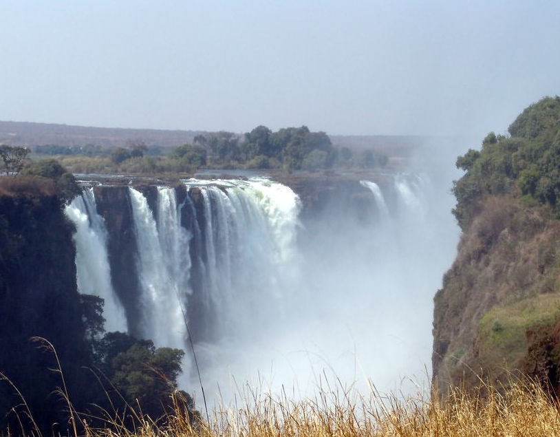
It covers an area of 335,000 hectares, and there are about 156,000 hectares of forest reserves around it, of which 90,000 hectares are located in the northern part of Tai National Park, which is adjacent to the Guiglo Reservoir in the north, and the two tributaries of the Cavali River flow through it and form the Seledeo Falls and Nava Falls, and the natural scenery is very beautiful. UNESCO listed it as a World Heritage Site in 1982 due to its diverse flora and fauna.
Five mammals are listed on the International Union for Conservation of Nature's Red List of Threatened species: Pygmy hippopotamus, green Colobus monkey, leopard, chimpanzee, and Jane's antelope. The park is the last remaining significant native tropical forest in West Africa. It has a wealth of natural plants and endangered mammal species, such as the dwarf hippopotamus and 11 species of monkeys, which are of great scientific interest.
(Komoai National Park)
The largest nature reserve in Cote d 'Ivoire. In the northeast, across the Comoi River. It covers an area of 950,000 hectares. Wango Fitini and Tehini are off-limits hunting centres. It is a tropical savanna. There are wild animals such as monkeys, antelopes, bison, elephants, lions and wild boars.
(The Bondama River)
A translation of "Bandama River". Largest river in Cote d 'Ivoire. It is formed by the confluence of the Baibangdama River and the Hongbangdama River. Originating in the eastern part of the Guinean Plateau, it flows from north to south across the country and empties into the Gulf of Guinea near Grau.
It is 780 kilometers long (counting from the upper source of the Dama River in Baibang) and covers an area of 97,000 square kilometers. The average downstream flow is about 700 m3 / s. It is navigable from the mouth of the river to Tiassaleh about 60 km. In the middle reaches, there is the Kosu Reservoir.