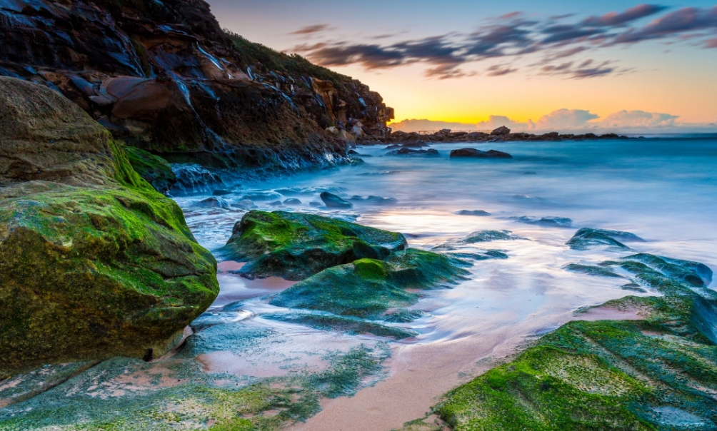
(Great Ocean Road)
Located in the west of Melbourne, Australia, it was built to commemorate the soldiers who participated in the First World War, and the people involved in the construction also included many war veterans, a total of more than 3,000 workers to pay for the hard sweat.
Construction of the Great Ocean Road began in 1919 and was completed in 1932. From the early 1980s, it was officially designated as a national natural park and opened to visitors. At the same time, the Great Ocean Road is also a common place name in China, and there is also a Great Ocean Road in Lishui city of Zhejiang Province and Beijing.
(Cocos Islands)/(Keeling Islands)
An Australian overseas territory in the Indian Ocean, the archipelago has a total population of 596 islanders, covers a total area of 14.2 square kilometers, and is made up of 27 coral islands. It was a territory of Singapore until 1955, and is one of the summer tourist attractions for domestic and foreign travelers.
(Heard Island and McDonald Islands/HIMI)An uninhabited desert island in the Southern Ocean about 1,600 kilometers south to the edge of Antarctica. Excluding Antarctica and islands with an area of less than 1,000 square kilometers, there is no land within a radius of 3,700 kilometers. It has been an Australian Overseas Territory since 1947.
(Byron Bay)
It is a small town famous for its beaches and lighthouses, located in the northeast corner of the bay of New South Wales, Australia, and the town's "Cape Byron" is the extreme eastern part of the Australian mainland. The name Byron Bay was given by Captain Cook, who discovered the Australian continent, after the grandfather of the famous poet George Byron, who once sailed around the world.
Byron Bay is Australia's new era of tourism paradise, known for its long surf beach line, iconic lighthouses, lush rainforests and colorful inhabitants, the origin of macadamia nuts. 70 km north of Byron Bay is Queensland's most famous Gold Coast; Byron Bay is 800 km from Sydney; Known as a New Age paradise, Byron Bay has long surf beach lines, iconic lighthouses, and lush rainforests.
(Moreton Island)
Located off the southeast coast of Queensland, Australia, across Moreton Bay and Brisbane, the capital of Queensland, an area of about 171 square kilometers, is the world's third largest sand island, 98% of the area is covered by national parks. Tenkaku Luma Resort is the only resort on the island.
It is famous for its wild dolphins, so it is also called "Dolphin Island". It is located in the Pacific Ocean, so you can see whales, seabirds, large schools of dolphins, and you can skate in the sand, but because few people know about it, there are not many tourists.
(WINEGLASS BAY)
More than 200 kilometres from Hobart, it is one of the top ten most beautiful bays in the world.
(Kakadu National Park)
Located in the northern Territory, it is about 320 km drive from Darwin, the capital of the Northern Territory, and borders Arnhem Land, the Aboriginal Autonomous Region of the Northern Territory to the east, with an area of 19810 square kilometers. There are both ancient features and modern active landforms. The oldest rocks here are over 2 billion years old.
Most of the land in the park has experienced severe weathering and leaching. There are four main land types in the park. Unique and complex ecosystems, tidal ebbs and flows, alluvial plains, lowlands and plateaus are ideal environments for a variety of unique flora and fauna. Kakadu National Park, a former indigenous autonomous region, was designated a national park in 1979, inscribed on the UNESCO Dual World Heritage List of Cultural and Natural Heritage Sites in 1981, and expanded in 1987 and 1992.
(Hutt Lagoon)
Located on the Indian Ocean coast in central Western Australia, it is one of the three pink lakes in Western Australia, of which the North Pink Lake Hutt Lagoon and the South Pink Lake Hillier Lake are the most scenic. Hutt Lagoon is about 520km drive from Perth, the capital of Western Australia, and about 100km drive from the coastal town of Geraldton on the west coast.
Located on the way from Perth to Kalbarri National Park, the usual route to Kalbarri National Park includes a stop at Hutt Lagoon. The town of Gregory is located between the Hutt Lagoon and the Indian Ocean coast. Hutt Lagoon is about 14 kilometers long, 2 kilometers wide and 70 square kilometers in area, with a shy pink color due to abundant algae and high salinity.
(Victoria Desert)
Located in southwest Australia, from the east of Lake Bally in Western Australia to the west of South Australia; It borders the Gibson Desert to the north and the Nalebo Plain to the south. It is 1200 kilometers long from east to west, with a maximum width of 550 kilometers and an area of about 300,000 square kilometers. The average elevation is 150-300 meters. Sand dunes and salt marshes. Plants are scarce.